Saturday, February 16, 2008

Southern Patagonia and the Southern Ocean

The Chilean Navimag ferry, Evangelistas, docked in Puerto Montt at 6 am on February 11. Hurriedly we grabbed our bags and ran for the bus station. Road weary, stuffed full of “Cruise” food, and beaten by the weather, we wanted on the first bus back to Temuco. In two weeks of travel around Southern Patagonia and the Southern Ocean we had seen enough of the wind, cold, fog, rain, and the roads – at least 50% in gravel. By 9am we were nestled in our seats, aboard a “directo” – a bus that makes only a few rural stops – headed north on Ruta 5, the main north/south freeway in Chile. As we progressed north the sky gradually cleared and the temperature rose. We scrounged our sunglasses from wherever they were packed long ago. In five hours we would be home to hot, sunny, smoggy Temuco.

As we reflected upon the privilege given to us to visit such an extreme environment, we decided to dedicate this next installment of our blog to the elements: the wind, the ice, the land and the sea. This is not to diminish the generous people we met, the moments we shared with our friends and new acquaintances, or the obstacles encountered and solved as travelers. The environment, the people, and the travel: together they blend as one to provide the texture of our experiences.
Wall art in Ushuaia
The end of the earth- al fin del mundo - is indeed a place of extremes: winds inconceivably strong, glaciers and ice fields so numerous and large that we can not mention them all , and a land dry, brittle, barren except for the impressive mountains and unique animals that have found a way to survive among the elements and with humans.


It is a solitary region, I have already spoken
of this so solitary region,
where the earth is covered with ocean,
and there is no one but some hoofprints
there is no one but the wind, there is no one
but the rain that falls upon the waters of the sea,
no one but the rain that grows upon the sea.

Pablo Neruda, The Southern Ocean

The Wind - El Viento

Blaine, Fran and friends Kate and Tito waiting to board the M/N Via Australias (Kate is the one with the camera.)
Our trip plan was to fly from Puerto Montt to Punta Arenas, Chile, stay for one night and then the fly to Ushuaia, Argentina. There were would stay for two days before boarding the M/N Via Australis (austral means southern) for a 4 day cruise of glaciers, penguins and the ultimate prize, Cape Horn. From the moment we stepped off the plane in Punta Arenas we were walking bent over. Punta Arenas is strategically located on the Straits of Magellan. It is a smallish, prosperous, industry-based city that just happens to be on the road to Cape Horn. They do a brisk – I mean that both in wind and $$ - business in international tourism from December to February. The rest of the year they act as Chile’s southern-most producer of gas as well as supplier of services and goods to points even further south including Antarctica. Docked in the city were military supply ships readying goods for transit to the South Pole.

Small boat harbor in Ushuaia. Note the boats are not on buoys.
We marvelled at how they did not break anchor - at least while we were there.
The wind did not relent in Ushuaia, it increased. Where Punta Arena hints at international tourism, Ushuaia reigns. Ushuaia is on the Beagle Canal in Argentina. Unlike cities in Chile it is not laid out around a central plaza. The theme in Ushuaia is tourist trap albeit with a European feel to it. The streets run parallel to the water front which helps to soften the strength of the wind coming off the Canal. As you rise up into the city, the first three to four streets are packed with tourist shops, restaurants, banks, and street vendors. Beyond that, were the regular folks live, are more restaurants, some hotels, and great views of the Canal. Situated at the base of a mountain Ushuaia even has its own glacier.
Work boats making way in rough seas off Isla Aguirre as we were approaching open ocean.


Rough seas and terrific vistas from the deck of the cruise ship.
We boarded the cruise boat in the evening after two days of sightseeing in Ushuaia. But the port was closed due to high winds, so we went to bed in our cozy cabins next to the dock. Thus set the tone for the rest of the trip: high winds, high seas, rain, mist, fog. We did not make it to Cape Horn. The winds were 95 miles per hour at the Cape. For this we forgave the captain his good judgment but we could not reconcile our disappointment. There were side trips to a calving glacier and to Isla Magdalena where a colony of 80,000!!! penguins live.
But always the eternally blowing wind dogged us.
The M/N Via Australis holding anchor in high wind at the Isla Magdelina.


Penguins dodging skuas and surf to fish.

The Land - La Tierra

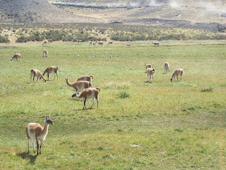
Guanaco herd grazing on the pampas grass.

Our cruise took us within the labyrinth of passages, fjords, and islands that comprise Tierra del Fuego. It is the largest island in South America. Yes, the wind does blow as we have mentioned but there is very little rainfall. If you think of eastern Oregon, Idaho, or Montana, you have an idea of the terrain and climate.

On February 6 we disembarked at Punta Arenas where we caught a bus to Puerto Natales gateway to the Torres del Paine National Park. This park is the premier park in Patagonia with the soaring peaks of the Torres as a backdrop for the numerous glacial lakes and streams. Made of solid granite, the Torres del Paine cordillera rises in pillars 2,800 meters above the Patagonian steppe. There are numerous guanaco, rhea (ostriches), flamingos, and Andean condors within the boundaries of the park which is a UNESCO biosphere reserve. The landscapes are truly astounding and we have vowed to return to join the more than 200,000 people who visit the park each year.

A surreal as it seems, that is NOT a poster in the background. We really were there.

The Glaciers - El Glaciars

Blaine, our friend, Tito Titus, and Glaciar Ghunther Pluschow
aboard the M/N Via Australis


One featured item in Southern Patagonia is glaciers. They are everywhere and very impressive. At first we had glimpses of them from a distance. As the journey progressed, we encountered glaciers in closer proximity. In fact, one cannot get a true feel for a glacier until its winds chill your body while a showery icy, mist rains on your face.

We had to be reminded that this was indeed summer in Patagonia. While on the cruise out of Ushuaia, we visited, in Zodiacs, a very blue thus ancient glacier with steep walls overhanging the fjord water. There we witnessed the glacier calve with the sound of a gun firing and the whoosh of the wind blowing across the water. The splash sent waves reverberating in the narrow fjord from which we viewed this cataclysmic event. We were coldly stunned by what we saw and experienced.

Glaciar Piloto y Nena calving.


This is not poor focusing; it alternated rain and sleet.


The best of the glacier watching was to come as we headed north on the Chilean Navimag ferry called Evangelistas from Puerto Natales to Puerto Montt from February 7 -11. This was a trip of over 1000 miles from Southern to Northern Patagonia through the inland fjords created by these same glaciers. Although the Navimag ferrys are essentially work boats carrying passengers and goods to inland ports, the captain took us to view several glaciers along the route. The most memorable is Glacier Skua. It is the most enormous glacier in Patagonia at approximately 50 kilometers wide and an incredible 140 kilometers long.
Glaciar Skua from the M/N Evangelistas about one mile away and up close.


The Sea - El Mar


Puerto Eden at dawn.

As the Navimag ferry made its way through the maze of passages that comprise the fjords and canals of Southern Chile, the inhospitable and dry terrain slowly morphed into the diverse and temperate rain forest of Northern Patagonia. A regular stop of the north bound Navimag is a very small and remote fishing village called Puerto Eden.

It is the stronghold where the last remaining group of Alacaluf indigenous people reside. With a backdrop of green foliage topped by the granite spires of the Andes, no neighbors for miles in any direction, and the only transportation by boat or sea plane, Puerto Eden is a unique community of 180 people that reminded us very much of the Alaska bush where we taught in the 1980’s.

Puerto Eden fishing boats await the tide.


Because there was no alternative, the ferry then headed out to the open ocean for a four hour sojourn on the Gulf of Pena before we could return to the calm confines of the canals and fjords. Heading North toward Puerto Montt, the last major crossing of open ocean was the Gulf of Corcovado which separates the mainland from the unique island of Chiloe. We will explore Chiloe in our next installment of the blog.